We have a proven track record of innovation in Survey Management Models for our clients. Our goal is not just to provide capacity but to enhance processes and deliver more adaptable and commercially viable solutions.
Since 2017, we have been offering geophysical and geotechnical Survey Management services. From 2018 to 2023, we were the largest provider of these services on the Norwegian Continental Shelf.
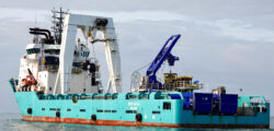
Recognising the increasing demand for additional capacity, we are excited to introduce a new and flexible solution designed to meet a substantial portion of the market’s need for geotechnical surveys. Introducing the M/V Ross Eagle, a dynamically positioned geotechnical investigation vessel.
M/V Ross Eagle
The M/V Ross Eagle is equipped to offer robust technical solutions for geotechnical seabed investigations.
Shallow- & deep-water operations:
- CPT 200kN / 20t
- 4,5” Cores
- Grab samples / baseline
- ROV (GVI) environmental investigation / mapping
- Grab for seabed
- 100 Te A-Frame above moonpool
- 50/100 Te AHC winch for subsea construction work
- 8Te CT winch for subsea construction work
GT Management
- Firm capacity in scheduled campaign
- Provision of turn-key Geotechnical and environmental solutions
- ISO certified processes, supported by our HSEQ department
- Optimizing acquisitioning during planning and operation
- Highly skilled and dedicated inhouse expertise up for any GT challenge
Reporting & Labs
- Offshore and Onshore geotechnical laboratory facilities
- Industry best practice lab analysis and reporting in line with ISO, DNV and Havtil
- Project specific lab analysis program and advisory
- Advanced sample storage and preservation techniques
M/V Sunny Lady
The M/V Sunny Lady is equipped to offer robust geophysical site investigation survey services.
Shallow- & deep-water operations;
- EM2040 MKII 0.7º: MBES / MBES backscatter/ water column data
- SBP Innomar Medium 2-22kHz
- SSS 4205 Edgetech Tri-freq 120/410/850kHz
- 1 x G882 Geometrics Magnetometer
- UHRS Sparker (80 channels @ 2m Group Interval)
- Starlink communication platform
- HiPAP positioning system
- Drop-down keel
SBP
Shallow subsurface: geohazard detection, ground modelling
Main characteristics
- SBP Frequency: 100kHz primary, 4-15kHz secondary
- Penetration: 10-15m depending on geology
- Vertical resolution : 0.25m
- Acquisition software: Innomar
- Interpretation software: Sonarwiz/Kingdom Suite
- Interpretation: cross correlation to UHRS for soil type zonation shallow features